September 29th, 2011 by Ricardo Píriz
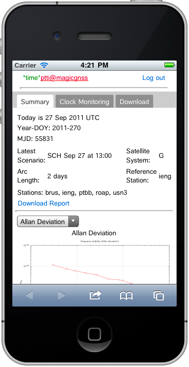 Time transfer via satellite is nowadays the primary means to synchronize distant atomic clocks on ground. Clock synchronization is fundamental for example for maintaining UTC (Universal Time Coordinated), the official scale by which the world regulates clocks and time. Computer servers, online services and other entities that rely on having a universally accepted time use UTC for that purpose.
Each national Timing Laboratory contributing to UTC keeps its own independent timescale, normally based on a very stable, temperature controlled, atomic clock or set of clocks. Then, all contributing timescales are inter-compared and combined in order to create an even more stable, international timescale (UTC).
But how to compare clocks located on different continents? One possibility is to use satellites that are in simultaneous view from the different laboratories. Enters GPS. By connecting each clock to a GPS receiver, in such a way that the measurements to the satellites are time-stamped by the external atomic clock instead of the internal receiver clock, and combining satellite measurements (RINEX files) from all these timing receivers in a sophisticated algorithm, it is possible to solve for all the system unknowns (satellite orbits, atmospheric delays, etc.) and compute the relative offsets of all ground clocks involved. This is precisely what the ODTS algorithm (Orbit Determination and Time Synchronization) within magicGNSS does. Read the rest of this entry »
Posted in Announcements | Comments Off on New app for clock synchronization via GPS
March 17th, 2011 by Álvaro Mozo
Some of the IGS stations placed in Japan are providing data after the magnitude 9.0 earthquake that hit Japan on March 11th, 2011. We have processed data from those stations with magicGNSS, to evaluate the site displacements due to the earthquake and its aftershocks. They are shown in the following graphic:
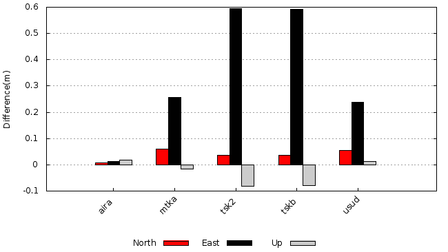
The pre- and post-earthquake coordinates have been computed with static PPP (GPS only, as most of the sites do not provide GLONASS data) using 1 day of data (March 10th and 15th, 2011, respectively).
Note that due to the aftershocks, the coordinates on March 15th may not be considered truly static, yet the results are considered very illustrative of the magnitude of the event.
Read the rest of this entry »
Tags: PPP
Posted in Events | Comments Off on Japan earthquake – IGS site displacements observed with magicGNSS
March 15th, 2011 by Álvaro Mozo
A 9.0-magnitude earthquake hit Japan on Friday March 11th, 2011 at 05:46 UTC. The epicenter was reported to be 130 kilometers (81 mi) off the east coast of the Oshika Peninsula, Tōhoku.
The National Astronomical Observatory in Mizusawa hosts a GNSS station which belongs to the IGS network. This station, labeled mizu, is located at around 140 km (87 mi) northwest of the epicenter, and provided GPS and GLONASS data at 1-sec rate until 06:00 UTC.
The following plots show the displacements of the mizu antenna coordinates during the earthquake, computed with magicGNSS’ GPS+GLONASS kinematic PPP. In both plots the positions are computed every second.
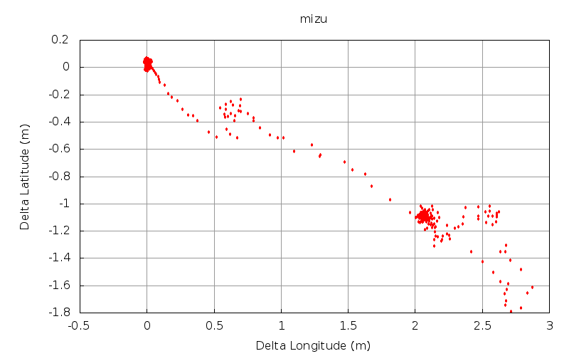
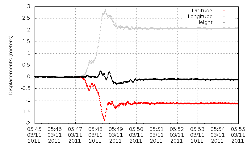
The IGS data from the mizu station for March 11th, 2011 used to compute the above plots have been made public in magicGNSS, so you can log into your account and process them yourself right now.
Tags: PPP
Posted in Events | Comments Off on The Japan earthquake observed by GPS and GLONASS
October 25th, 2010 by Ricardo Píriz
Precise Point Positioning (PPP) is normally understood as a global positioning service, since precise satellite orbit and clock products used as input in PPP are best calculated using a network of GNSS reference stations distributed worldwide.
However orbit and clock corrections for PPP can also be provided over a world region in a similar way to WAAS or EGNOS corrections. It is even possible to provide a national PPP service over a single country, using national GNSS stations exclusively.
Satellite orbits and clocks calculated using regional stations do not have of course a high overall accuracy, but they do have a higher accuracy over the service area and, most importantly, orbit and clock errors largely cancel out over the service area. For a static or kinematic PPP user located inside the region, positioning accuracy using global or regional products is very similar.
In magicGNSS version 3.1 it is possible to evaluate the performance of regional PPP in a very simple way. Just process an ODTS scenario to calculate orbits and clocks covering the time period of your interest. On the Stations tab, select stations over your region only. Click on the station icons to select/deselect, you can use core stations and/or your own stations.
In regional ODTS it is better to deselect “Refine Station Coordinates” in Settings. Core stations have already precise coordinates, and for your own stations you are supposed to have processed them beforehand in PPP using the “Update My Station Coordinates” option. Try also to use a longer ODTS scenario duration (3 to 4 days), in order to maximize satellite visibility. It is also important to select a good reference clock in ODTS. The reference clock time should be close enough to UTC (or GPS Time), with an offset of the order of the microsecond or less. You can see the offset of a station clock by processing it in PPP.
When ODTS processing is ready, create a new PPP scenario for that period, and select Products from the ODTS scenario you just processed, instead of the global ones (Operational):

You can use COMP to compare static or kinematic PPP solutions using global and regional products.
Posted in Announcements, Tips & Tricks | Comments Off on Regional PPP
October 6th, 2010 by Ricardo Píriz
It is now possible to process kinematic data in the latest magicGNSS version (3.0). Precise Point Positioning (PPP) supports now both static and kinematic modes, including GPS-only, GPS+GLONASS, and GLONASS-only data.
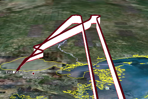
Flight over Louisiana (from the Kinematic GPS Challenge)
You can download this KML file generated by our kinematic PPP, and corresponding to one of the flights from the Kinematic GPS Challenge. In Google Earth, use Shift-s and scroll with the mouse to see the flight in perspective.
Combined GPS+GLONASS products used by PPP (satellite orbits and clocks) are internally generated with a 30-min latency. Note that our internal clocks have a 5-min rate. Final IGS products provide clocks at a 30-sec rate (GPS only), and they are used by our PPP when they become available (2-week latency).
Posted in Announcements | Comments Off on Kinematic positioning now available
 Time transfer via satellite is nowadays the primary means to synchronize distant atomic clocks on ground. Clock synchronization is fundamental for example for maintaining UTC (Universal Time Coordinated), the official scale by which the world regulates clocks and time. Computer servers, online services and other entities that rely on having a universally accepted time use UTC for that purpose.


