Archive for the ‘Tips & Tricks’ Category

Regional PPP

October 25th, 2010 by Ricardo Píriz

Precise Point Positioning (PPP) is normally understood as a global positioning service, since precise satellite orbit and clock products used as input in PPP are best calculated using a network of GNSS reference stations distributed worldwide.

However orbit and clock corrections for PPP can also be provided over a world region in a similar way to WAAS or EGNOS corrections. It is even possible to provide a national PPP service over a single country, using national GNSS stations exclusively.

Satellite orbits and clocks calculated using regional stations do not have of course a high overall accuracy, but they do have a higher accuracy over the service area and, most importantly, orbit and clock errors largely cancel out over the service area. For a static or kinematic PPP user located inside the region, positioning accuracy using global or regional products is very similar.

In magicGNSS version 3.1 it is possible to evaluate the performance of regional PPP in a very simple way. Just process an ODTS scenario to calculate orbits and clocks covering the time period of your interest. On the Stations tab, select stations over your region only. Click on the station icons to select/deselect, you can use core stations and/or your own stations.

In regional ODTS it is better to deselect “Refine Station Coordinates” in Settings. Core stations have already precise coordinates, and for your own stations you are supposed to have processed them beforehand in PPP using the “Update My Station Coordinates” option. Try also to use a longer ODTS scenario duration (3 to 4 days), in order to maximize satellite visibility. It is also important to select a good reference clock in ODTS. The reference clock time should be close enough to UTC (or GPS Time), with an offset of the order of the microsecond or less. You can see the offset of a station clock by processing it in PPP.

When ODTS processing is ready, create a new PPP scenario for that period, and select Products from the ODTS scenario you just processed, instead of the global ones (Operational):

You can use COMP to compare static or kinematic PPP solutions using global and regional products.
Ocean loading

January 18th, 2010 by Álvaro Mozo

Ocean loading is the deformation of the Earth due to the weight of the ocean masses. The water in the ocean moves due to the gravitational pull of the Moon and the Sun (this is the tides), and causes the Earth, which is not completely rigid, to deform according to the varying load of the ocean’s water. The deformation is periodic, following the relative motion of Earth, Moon and Sun, however such relative motion is rather complex and thus periodicity has to be represented with several harmonic terms of different period.

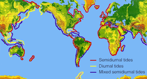
Periodicity of tides around the world (graphic from NOAA)

Periodicity of tides around the world (graphic from NOAA)

Most commonly, the 11 first terms (i.e. those with higher amplitude) are retained to model this effect.

Ocean loading can be perceived as a periodic displacement of the station position (especially in coastal areas), as well as a periodic variation of the Earth’s gravity.

How is ocean loading taken into account in magicGNSS?

(more…)

Automating data processing with the Scheduler

October 21st, 2009 by Ricardo Píriz

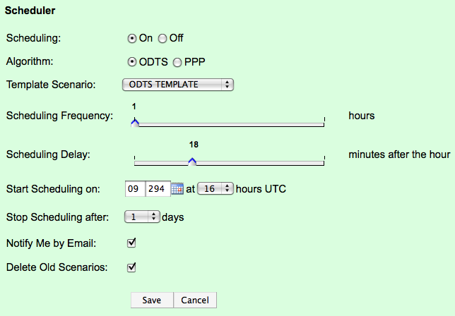
With the latest version of magicGNSS (1.4), and if you have a *pro* account, you will be able to automate your station data processing in ODTS or PPP, using the new Scheduler. This is how the Scheduler settings look like:

Scheduler

Just select the algorithm you want to automate (ODTS or PPP). Previously you should have run an ODTS or PPP scenario to be used as template by the Scheduler. Every time it runs, the Scheduler reads the scenario Duration, the list of Stations, and the Settings, from the template scenario. Make sure your template scenario is properly configured! (more…)

GPS antennas and positioning

July 24th, 2009 by Ricardo Píriz

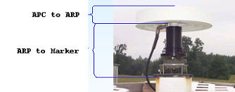
In GPS antennas, there are three important reference points that have to be considered, as shown in the following picture (borrowed from NRCan):

arp

The Antenna Phase Center (APC) is the virtual electronic point that actually tracks the GPS signals. In principle, coordinates from any GPS receiver or station refer to this point.

However, for geodetic applications, since the antenna might be replaced by another model at some time, it is important to consider a physical point attached to the ground. This is called the Marker. (more…)

(Deprecated) About station icons

May 28th, 2009 by Ricardo Píriz

This information is deprecated, please visit the new post.

Just a quick explanation about the meaning of station icons in magicGNSS:

GPS+GLONASS core station

GPS core station

deselectedDeselected station

reference_clockReference clock (in ODTS)

GPS+GLONASS user station with precise coordinates

GPS+GLONASS user station (or rover) with approximate coordinates

GPS user station with precise coordinates

GPS user station (or rover) with approximate coordinates

GPS+GLONASS public station with precise coordinates

GPS+GLONASS public station with approximate coordinates

GPS public station with precise coordinates

GPS public station with approximate coordinates