Archive for the ‘Announcements’ Category

Regional PPP

October 25th, 2010 by Ricardo Píriz

Precise Point Positioning (PPP) is normally understood as a global positioning service, since precise satellite orbit and clock products used as input in PPP are best calculated using a network of GNSS reference stations distributed worldwide.

However orbit and clock corrections for PPP can also be provided over a world region in a similar way to WAAS or EGNOS corrections. It is even possible to provide a national PPP service over a single country, using national GNSS stations exclusively.

Satellite orbits and clocks calculated using regional stations do not have of course a high overall accuracy, but they do have a higher accuracy over the service area and, most importantly, orbit and clock errors largely cancel out over the service area. For a static or kinematic PPP user located inside the region, positioning accuracy using global or regional products is very similar.

In magicGNSS version 3.1 it is possible to evaluate the performance of regional PPP in a very simple way. Just process an ODTS scenario to calculate orbits and clocks covering the time period of your interest. On the Stations tab, select stations over your region only. Click on the station icons to select/deselect, you can use core stations and/or your own stations.

In regional ODTS it is better to deselect “Refine Station Coordinates” in Settings. Core stations have already precise coordinates, and for your own stations you are supposed to have processed them beforehand in PPP using the “Update My Station Coordinates” option. Try also to use a longer ODTS scenario duration (3 to 4 days), in order to maximize satellite visibility. It is also important to select a good reference clock in ODTS. The reference clock time should be close enough to UTC (or GPS Time), with an offset of the order of the microsecond or less. You can see the offset of a station clock by processing it in PPP.

When ODTS processing is ready, create a new PPP scenario for that period, and select Products from the ODTS scenario you just processed, instead of the global ones (Operational):

You can use COMP to compare static or kinematic PPP solutions using global and regional products.
Kinematic positioning now available

October 6th, 2010 by Ricardo Píriz

It is now possible to process kinematic data in the latest magicGNSS version (3.0). Precise Point Positioning (PPP) supports now both static and kinematic modes, including GPS-only, GPS+GLONASS, and GLONASS-only data.

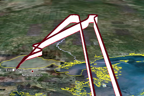
Flight over Louisiana (from the Kinematic GPS Challenge)

You can download this KML file generated by our kinematic PPP, and corresponding to one of the flights from the Kinematic GPS Challenge. In Google Earth, use Shift-s and scroll with the mouse to see the flight in perspective.

Combined GPS+GLONASS products used by PPP (satellite orbits and clocks) are internally generated with a 30-min latency. Note that our internal clocks have a 5-min rate. Final IGS products provide clocks at a 30-sec rate (GPS only), and they are used by our PPP when they become available (2-week latency).

Autonomous integrity

August 4th, 2010 by Ricardo Píriz

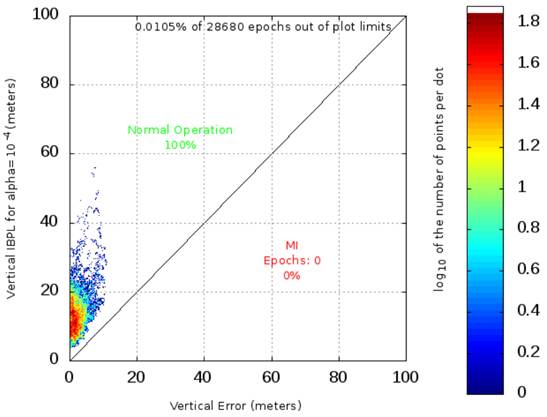
magicGNSS version 2.5 is now available incorporating the IBPL algorithm supporting GPS+GLONASS. IBPL stands for Isotropy-Based Protection Level, a proprietary algorithm developed by GMV for autonomous pseudorange-based user receiver integrity.

The new IBPL module within magicGNSS is a demonstrator of the IBPL concept, but of course not an operational software, since IBPL is intended to run inside the user receiver.

Example of Stanford diagram from IBPL

Example of Stanford diagram from IBPL

(more…)

PPP now supporting GPS and GLONASS real-time data

May 13th, 2010 by Ricardo Píriz

The Precise Point Positioning (PPP) module in magicGNSS is now capable of processing GPS and GLONASS data just acquired, in RINEX format.

Real-time GPS and GLONASS orbits and clocks needed by PPP are generated internally. Orbit and clock products are generated twice per hour (at 00 and 30 minutes) with a latency of 30 minutes. The internal time scale for satellite clocks is driven by an on-ground H-maser.

When rapid and final GPS orbits and clocks from IGS become available, PPP uses them instead of our internal products. For GLONASS, our internal products are still used but satellite clocks are post-processed to be aligned to IGS Time. Therefore it is always possible to combine GPS and GLONASS in PPP.

GLONASS products are only available starting 2010/01/01.

PPP now supporting ETRS89 in Spain

March 8th, 2010 by Ricardo Píriz

magicGNSS now supports the ETRS89 coordinate reference system in Precise Point Positioning (PPP). ETRS89 has been recently declared the official reference frame in continental Spain. ETRS89 stands for European Terrestrial Reference System 1989. In this system the coordinates are “frozen” at the 1989.0 epoch (1st of January 1989), in order to maintain a network of stable reference landmarks throughout the country, considering that the Eurasian tectonic plate drift is around 2 cm per year on Spain.

PPP uses as input satellite orbits given in the global ITRF05 system (actually IGS05, the IGS realization of ITRF05). Therefore the resulting user receiver coordinates are given in ITRF05 too, and they are estimated at the date of the user measurements. For users in Spain we are now converting these ITRF05 coordinates to ETRS89 and reporting them in the PPP outputs.

How do we do the conversion from ITRF05 to ETRS89? We take as reference a set of 23 fiducial GNSS stations located all over Spain and maintained by the IGN, the Spanish national mapping agency. Only stations on the Iberian Peninsula are chosen. For these stations, every month we process offline one day of data in PPP, and then we do a Helmert transformation between the official ETRS89 coordinates published by the IGN and our PPP solution in ITRF05. Then, at PPP user level, we apply the Helmet transformation parameters in the opposite direction in order to obtain the ETRS89 user coordinates.

The residual fit after the Helmert transformation between ITRF05 and ETRS89 for the 23 IGN stations is around 6 mm only (3-D RMS). This means that the loss of accuracy at user level due to the conversion to ETRS89 is well below the cm, which is at the same level as the PPP accuracy itself.