GPS antennas and positioning
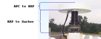
July 24th, 2009 by Ricardo PírizIn GPS antennas, there are three important reference points that have to be considered, as shown in the following picture (borrowed from NRCan):

The Antenna Phase Center (APC) is the virtual electronic point that actually tracks the GPS signals. In principle, coordinates from any GPS receiver or station refer to this point.
However, for geodetic applications, since the antenna might be replaced by another model at some time, it is important to consider a physical point attached to the ground. This is called the Marker.
The link between the APC and the marker is not direct, because the APC is an electronic point whose location changes a little bit with the antenna-to-satellite signal azimuth and elevation. In order to take this effect into account the antenna is calibrated with respect to the so-called Antenna Reference Point (ARP).
Normally the ARP is simply the center of the antenna baseplate (bottom). Antenna calibrations are maintained by IGS in their latest ANTEX file. The antenna information is contained in the “ANT # / TYPE” record on the RINEX measurement file header.
The distance between the ARP and the Marker is contained in the “ANTENNA: DELTA H/E/N” record on the RINEX file header.
In magicGNSS, the Precise Point Positioning algorithm reports the Marker coordinates. If for any reason you need the average APC coordinates from PPP, simply remove all antenna information from the “ANT # / TYPE” record (but not the record itself!), and set all values on the “ANTENNA: DELTA H/E/N” record to zero, and then process the RINEX file with PPP.


