ODTS versus PPP coordinates
October 9th, 2008 by Ricardo PírizAs explained in the previous entry of this blog, the ODTS algorithm inside magicGNSS is able to calculate precise station coordinates. Another technique that is becoming increasingly propular to calculate receiver coordinates is Precise-Point-Positioning (PPP).
The main difference between ODTS and PPP is that ODTS is a multi-station global solution that calculates also satellite orbits and clocks, and PPP is a single-station technique where satellite orbits and clocks are solved beforehand using an independent software (or are fixed to IGS solutions). ODTS is based on a batch least-squares algorithm whereas PPP is normally based on a sequential filter that solves for the user reciever coordinates, clock, tropo, and phase ambiguities.
Two examples of online PPP services are NRCan’s PPP and JPL’s APPS. These two web sites allow the user to upload one or several RINEX data files, process them using PPP, and then download the results in a very simple and convenient way.
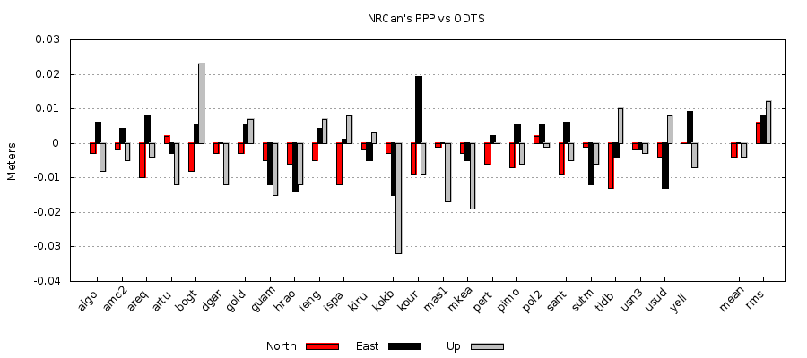
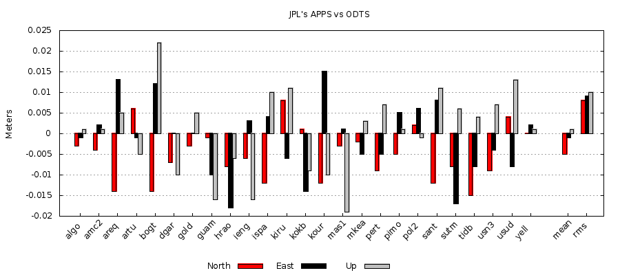
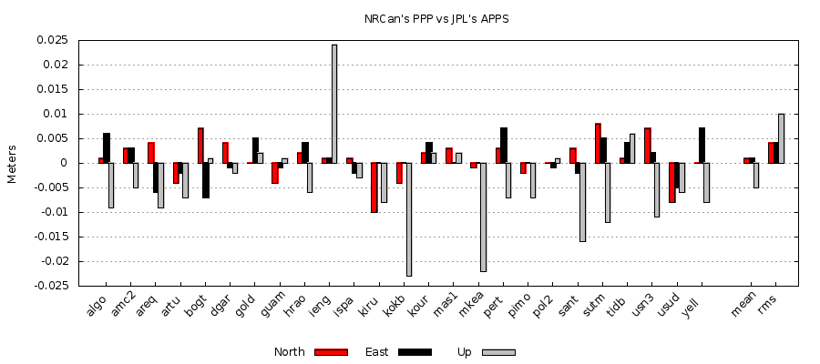
We have done an experiment to compare the coordinates calculated by ODTS and PPP for a set of 25 IGS stations. Daily RINEX files (@30 sec) for Sep 26 2008 (DOY 270) were downloaded from IGS and then uploaded to NRCan’s PPP and JPL’s APPS web services. In parallel, a 2-day ODTS scenario was run in magicGNSS (days 270 and 271). The data used by ODTS is not exactly the same as the data used by the PPPs, although the stations are of course the same ones. ODTS uses the 15-min RINEX files (@1 sec) stored in the magicGNSS server (core stations).
All services (ODTS and PPPs) were configured to use a 10 deg elevation angle cutoff. All services refer the resulting coordinates to the antenna marker in a cartesian Earth-fixed frame, therefore it is straightforward to compare coordinates, just a transformation to local coordinates (from X-Y-Z to North-East-Up) is done using the WGS84 ellipsoid. ODTS uses a priori coordinates from ITRF or IGS, extrapolated to the scenario date using station velocities. The PPP services use the approximate coordinates in the RINEX file header as a priori values (in some cases they can have errors of meters). The comparison results are shown in the following figures and I think they speak by themselves!


