Georeferencing
October 14th, 2008 by Ricardo PírizDid you ever wonder how we draw our station icons (![]() ) on Google Maps? We simply convert our Earth-centered Earth-fixed cartesian station coordinates (X-Y-Z) to geodetic coordinates (latitude-longitude-height) using the WGS84 ellipsoid implemented in Google Maps (and using as many decimals as possible!) Then we use the Google Maps API to render the icon at the desired location.
) on Google Maps? We simply convert our Earth-centered Earth-fixed cartesian station coordinates (X-Y-Z) to geodetic coordinates (latitude-longitude-height) using the WGS84 ellipsoid implemented in Google Maps (and using as many decimals as possible!) Then we use the Google Maps API to render the icon at the desired location.
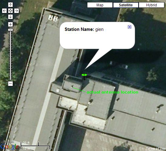
But when we zoom in at the maximum level in Google Maps using satellite imagery we observe that most of the times the icon does not coincide with the actual position of the station antenna on the image. The image below shows the “gien” station antenna on the roof of INRiM, the Italian metrological institute in Turin. The station icon is around 5 meters away from the actual antenna!
How is this possible? Didn’t we say in a previous post that our coordinates have an accuracy of a couple of centimeters? The answer is that satellite images on Google Maps are in general georeferenced with an accuracy of just a few meters, which is of course enough for most users. For example if you use a normal handheld GPS receiver you get a positioning error of several meters, which is usually good enough to navigate through streets and roads without the need of a perfectly georeferenced map.


